
Indian Creek Trail, Stanislaus National Forest: From Groveland down to the Tuolumne River
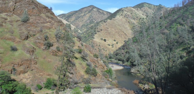
I like to think that part of the allure of the upper Tuolumne River is that it is a little mysterious. My house in Groveland, CA is about three miles from the Tuolumne as the crow flies, but it’s not a simple hop, skip, and jump over to the river. Yes you can drive down to the Tuolumne on Forest Service roads, but you will know you are driving down into a river canyon. These are often one lane roads that precariously protrude from the sloped walls. Roads like Lumsden Road are one landslide away from being covered in debris or falling off the side of the cliff. Plus they are not very passanger car friendly.
But I feel the need to take that journey every once in a while, to enjoy the beautiful wild and scenic river that flows right past our little town. With that in mind, why not consider enjoying the journey? Instead of white knuckle driving I propose an alternative: The Indian Creek Trail.

Indian Creek Trail, Stanislaus National Forest
Trailhead: From Highway 120 turn onto Ferretti Rd and turn onto Clements Rd (North side of Ferretti, just past the Pine Mountain Lake Stables). Here follow the signs to the trailhead. The road after Clements gets pretty rough, I personally wouldn’t bring a passenger past where the road narrows. Rough Map (beware google hasn’t gone up here yet)
Distance: 3 miles down to the river from the trailhead (6 round trip). Longer if you park further up the road. It is a steep 1600+ ft decent, but the switchbacks are actually pretty well spaced. Watch out for poison oak and river rattlesnakes.
This is a spring hike: Wildflowers, cooler temps, and cool water releases from Hetch Hetchy make spring the perfect time to hike down to the Tuolumne. It has been a weird wildflower season this year, some flowers popping super early and others seeming to never come out, Here an eclectic mix was sticking out, despite the drought, on the way down. I would love to see the canyon covered in poppies. Maybe next year? It is after all, just a hop, skip, and rather long descent down from Groveland!
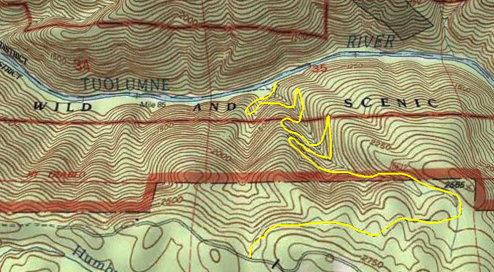
Not a very accurate path, but gives you an idea of how steep this trail will be.


 Hello! I am a 30-something outdoors-lady, backpacker, and resident of Groveland, California -
He Denise, I am interested in trout fishing that part of the Tuolumne, any info? Once you get down there, can you keep going upstream? What is it like?