
Michigan Shore-to-Shore Trail
The last couple of days I have spent my days in the Northern Lower Peninsula of Michigan – visiting with my granny and aunt (and mom!), enjoying Lake Huron’s sandy shores, and by surprise discovering the Michigan Shore-to-Shore Trail while trail running this Friday. Although I have never heard of the Michigan Shore-to-Shore trail before, this 220-ish mile trail trekking from Lake Huron to Lake Michigan has me wondering how I have not run into this trail before – or even heard of it!
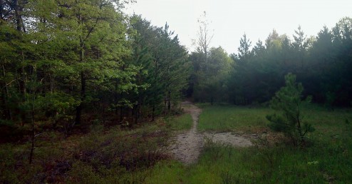
A point on the trail where the dense forest opened up allow the sunlight to break through.
Michigan Shore-to-Shore Trail
Trailhead: Because this trail is from shore to shore, in theory you should start the hike at Lake Huron – I am not sure if there is an official spot, but the Oscoda beach park make sense as a public area. What I found when running was the start of the on trail section (pririor the “trail” travels along road through the city of Oscoda). The trail I found starts outside of town and up Old US 23 past the industrial park (map here) on the left hand side of the road.
Distance: The total distance is listed on many website as 220 miles (although I am not sure if that includes a few spurs off the main trail). Personally I ran ~2 miles on the trail, and can only vouch for that 1% of the total distance.
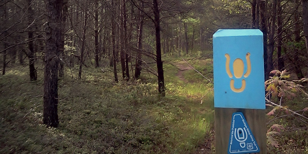
While running down Old Hwy 23 from Oscoda I saw some hiking/equestrian trail marker tags leading to a trail off the road at very arbitrary point. There was no parking lot, no large pullout, and besides the blue triangle trail markers no signs. In the spirit of exploration and fresh air I started down the trail, which was surprisingly a very good running path. There were minimal roots on this section, and the sandy path was never too loose as to make running difficult. I traveled through the densely wooded path until I reached a dirt road (Grass Lake Rd) where the path ended neat a larger trail sign.

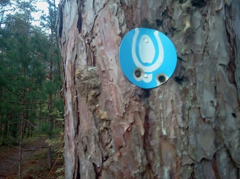
More traditional looking circular markers are mixed among the specific triangular trail markers – but all sharing the dual equestrian/hiking logo.
Figuring I would complete the loop by traveling north back to Old US 23, instead I found that the trail continued on the other side of the road with a similar trail sign started on the West side of the road up here. This section of the trail follows an old two track, with a few obstacles to dissuade ORV use. Before turning around my running path crossed ways with a couple wild turkeys, a white tail, a multitude of song birds, and an army of mosquitoes. Once turned around to make my way back to Oscoda I ran into a friendly horse man, enjoying the trail before the weather got too hot that day, assuring me that this was not just an abandoned trail along the side of the road.
Michigan Shore-to-Shore Trail Map
Curious about the path when I got home I started Googling and quickly figured out it must have been the Shore to Shore trail. This trail is primarily used by equestrian traffic (like the friendly horseman I had met), but lacks easily available maps on the route. The Michigan Trail Riders Association appears to have the most experienced with the trail, but do not offer useful online maps, although they will sell you map (which may or may not be accurate enough for hikers). After digging deeper into the search results deep did find what I am calling the best complete map and Shore to Shore trail GPS tracks on outdoormichigan.com. They also have a KML track that you can put straight onto Google Earth, shown below.
Perhaps someday I will be in the position of trying to find a good length of backpack-able trail in lower Michigan, in which case I would consider looking further into the shore-to-shore trail. The populated sections, mosquitoes, and sandy trail makes it a less than perfect trail, but I still find it a really intriguing sounding challenge. Maybe it is only because it is a under hiked trail in an area where there is little else to hike, but I think conquering this 220 mile beast section by section would be a satisfying feat. Maybe someday!


 Hello! I am a 30-something outdoors-lady, backpacker, and resident of Groveland, California -
Hello Denise,
I have a similar story – but I stumbled upon the trail in the mid 1970s when my brothers and Dad and I decided to hike a portion (Oscoda to Mio). Of course we didn’t do well without the correct equipment or preparations and NO experience and we ended up hitching a ride from one of the Au Sable River Dams (don’t recall which) to Mio. I vowed to hike it again some day and started researching it a few years ago before my 50th birthday and found there is next to no information. I bought a map from the MTRA and it was “ok”. I intended to do the trail in 2 or 3 sections, but it took me 4 (for several reasons). Anyway – I am planning a thru-hike the spring/summer 2015 to start preparing me for thru-hiking the AT in 4 years when I’m thinking about retiring. I would not say I’m an expert, but know the trail very well end-to-end (stops, stores, water, camping, lesson-learned, and motels/cabins along the way for an occasional furlough from the trail). I don’t know anyone else who has actually completed it on foot. Drop me an email if you have questions. kfilar@woh.rr.com