
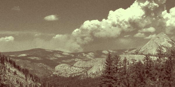
The Rim Fire from Groveland
In case you have not heard, the big news around Groveland & this stretch of of the Sierra recently has been the Rim Fire, currently at 228,680 acres & the 4th largest wildfire in California history. Curtis, I, and our pets (Basil and Herman) are now back at home and safe, but it was an adventure getting here! We survived home evacuations, road closures, visitors, and backpacking trips during this chaotic time. I am going to start out this blog with my 5 Wildfire Lessons, and then continue to tell my story of how quiet town like Groveland, not to mention my backpacking plans with my 5 closest friends, was shaken up by this act of nature.
5 Wildfire Lessons
Obviously if you need to get out of town ASAP – grab what you need, and plans will follow. But, here in Groveland we had a more than enough time to anticipate evacuation, and here are some things I learned while laying low and seeing how things would play out:
1. Evacuating pets is something everyone needs to be prepared for. In addition to pets and their immediate supply needs grab any pet paperwork. Luckily mine was with the drawer of important documents I had already thrown in the car. I needed proof of distemper shot (FVRCP) for the “Kitty Hotel” Herman visited while we were backpacking. Vet records are always good too!
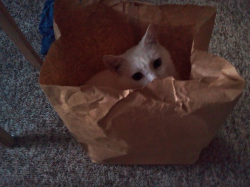
Herman prepared himself for evacuation inside of this paper bag – he was upset when I informed him he had to go into the cat carrier instead. Poor little guy!
2. Rumors can get crazy in a small fire panicked town, and although they might be the best gossip this place has had in years, go straight to the source when it concerns your own safety. I followed Inciweb, which generally updated once or twice a day, more often for additional closures/evacuation notices.
3. Take the opportunity to reinvest in your local community. Here in Groveland the community has hung signs everywhere thanking the firefighters and emergency personal for helping to keep our homes safe – but the fire is still “burning” away at the tourism dollars our local businesses depend on to keep them afloat (The LA Times even ran a lifestyle piece about this). Plus now everyone automatically has a common interest, lets all be friends!
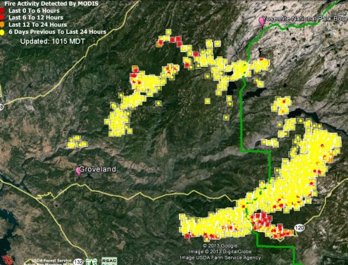
Today’s Conus Fire polygons on Google Earth. You can see the fire is not burning as quickly or very close to Groveland anymore.
4. Maybe your home is not in danger, but you want to see how a wildfire might effect your backcountry hike? You can check the current spread of a fire using realtime satellite data on Google Earth. Find the fire in question and see where the fire is burning hot (indicated by red squares) and has the most potential to spread. Additional information may additionally be available through hiking rangers and personal. For example Yosemite has set up alerts & backcountry boundaries in the park to stop anyone from traveling into the most dangerous sections.
5. Consider air quality and smoke when planning hikes anywhere in the vicinity of a large wildfire. Smokey air can ruin a vista, and is a big concern for anyone with respiratory issues. For the Rim Fire the smoke has been effecting air quality as close by as the Yosemite Valley and as far away as Tahoe, dependent on winds and local weather patterns. There are a number of tools to monitor air quality including: a realtime interagency air quality report from the forest service, BLM, and Department of Fish and Wildlife which ranks air quality near fires from “Good” to “Hazardous”, Air Quality Alerts from the National Weather Service – they will pop up if there is a an alert in the county/area you have searched, and for wildfires in the state of California local regional Air Quality Management District may have some more specific info.
Brief history of the Rim Fire
Some background before I start on my personal Rim Fire Story: The Rim Fire started on August 17th, in the Groveland District on the Stanislaus National Forest near the confluence of the Clavey and Tuolumne River – a spot I had the privilege of rafting past just a month ago. Although the official cause is undetermined, if you listen to this YouTube video some are guessing the cause is illegal pot grows on the forest. The Tuolumne river canyon is difficult place for the firefighters because of the steep terrain, combined with the drought dried fuels, leading to a hard to contain and growing fire. In fact, this same area of the forest experienced a large, and deadly, fire (The Tuolumne Fire) just under a decade ago.
My Story of Hiking Preparation During a Time Fire and Uncertainty.
The start of the Rim Fire coincided with my preparation and the arrival of 4 of Curtis & I’s midwestern friends for our annual backpacking trip. I have been excited about this trip for a whole year prior – but knew many preparation tasks could only be complete at the last minute. The result was a busy and preoccupied Denise, I knew the fire had started on Saturday, but it seemed fine – small fires had been cropping up in California all month. On the second day of the fire I made the trip to Yosemite down Hwy 120, which would turn out to be the last day Hwy 120 was opened to enter the park for non-emergency personal. My regret – I was to busy to even stop to Gawk at the billowing smoke column at Rim of the World vista (the fire’s namesake). On day three I was running errands in Sonora like buying backpacking food (still a necessary task) and cleaning linens (Ultimately unnecessary since our friends never came to the house) as the smoke filled the air.
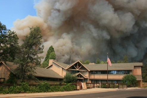
Curtis’s office right as the evacuation happened. Photo courtesy of the USDA Forest Service, and if Curtis told me correctly photographer & friend, Dusy Vaughn
Sh-tuff got real as Curtis called as I was driving to the laundrymat, informing me that the fire had jumped the highway (120), arriving essentially to the doorstep of his Forest Service office, followed by a prompt evacuation of all personal. The laundromat’s choice radio station – 92.7 “Today’s Hits and Yesterdays Favorites” for your workday – had changed their programming from generic pop to a constant Rim Fire update stream. The news? Highway 120 is closed past Smith Station, the town of Buck Meadows is evacuated, don’t even think about getting into the park via the Big Oak Flat entrance station.
Two days latter, one day before the midwesterners would arrive, I realized that we would be unable to pick up our backpacking permits before we would have to catch the bus in Yosemite, a logistical panic that caused me to drive to Mariposa to enter the park through El Portal to ensure the trip would go as planed. At the end of my 4 hour round trip drive I start heading up Old Priest Grade and was greeted by a rush of vehicles headed down the grade – It turns out advisory evacuations had been issued for the entire Pine Mountain Lake community (where I live). Bad news for someone who was planning to have 4 people visit, and leave their pets behind for a couple of days.
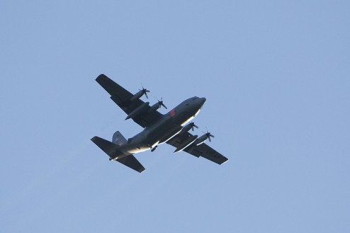
There was a constant flow of air traffic over our home during the fire. This photo is courtesy of Velo Steve on Flickr Creative Commons since we did not manage to get any picture worth our while.
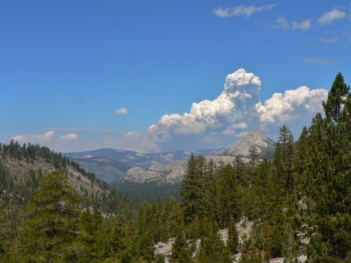
After a change of plans we hiked in the Southern part of Yosemite with our 4 friends, this was our view of the fire on the hike to Ottoway Lake.
Long story short, we ended up taking our pets to kennels in the San Francisco area, taking our friends everywhere but Groveland, and eventually returning home safely still 2 persons & 2 pets a few days ago. Groveland is no longer in any imminent danger, but feeling the impact of the fire on labor day tourism. Stepping outside in the morning here is like walking into an ashtray, but the smoke lifts by late day. Curtis has started back at work, and will likely be busier than normal dealing with the fire and resulting mess for a couple on months. Ultimately, I am just glad to be home.


 Hello! I am a 30-something outdoors-lady, backpacker, and resident of Groveland, California -
I had such an amazing time, fire and plan 8002 b and all, but I’m still so sorry about everything you went through to get us to that point. Thank you so much for everything. I am most glad you’re all back home safe.