
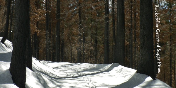
Rockefeller Grove, Yosemite – Sugar Pines, Skiing, & Fire Scars
Yosemite is know for having three giant sequoia groves (Mariposa, Merced, & Tuolumne), but did you know about the park’s less visited Sugar Pine Grove, the Rockefeller Grove? I hadn’t either until Curtis had mentioned it as an option for a late season cross country ski trip. He had heard about it as one of the spots fire crews had worked to protect from the rim fire, one of the oldest groves of un-logged Sugar pines. Sure enough, after consulting what the Crane Flat winter trail map, the Rockefeller Grove was clearly marked.
Skiing the Rockefeller Grove, Yosemite
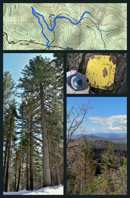
Distance: We did 2.25 miles out (4.5 round trip) but turned around early because the snow was starting to torn to slush. The map shows the trail ending at around 2.75 miles out. To get out the burned are it is about a mile and a half – after which the sugar pines are easier to spot. See Yosemite’s Map
Trailhead: Park at the Merced Grove parking lot, and cross the street turning left (West). Shortly you will find a gate and a sign urging you not to trample the ski trails. The trailhead is currently unsigned besides this. Map
Along the way to the grove there are remnant from the time the Forest service managed this land, some views of the rim fire, and (of course) sugar pines!
Rockefeller Grove is my new favorite easy ski in the park, helped by the fact that it was my only ski this drought filled winter. It’s slight uphill climb the whole way out is not too tiring, but making for an enjoyable quick ski back down to the car. Curtis and I were breaking new trail the entire time, which is a good thing when the snow turns to slush as quickly as it did.
The first mile and half of the trail is through a intensely burned forest, morphing then into the parts saved from the hottest blazes of the fire. I assume this second section is considered “The Rockefeller Grove.” I am assuming because, unlike the giant sequoia groves, sugar pines do not grow in such notable clusters. Instead sugar pines, including the nice big ones found back here, give the forest a unique look and lush feel. Plus, if you visited this area without the snow you would no doubt find some magnificent large sugar pine cones littering the ground.
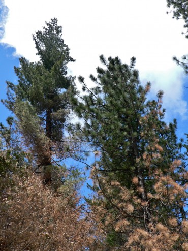
The tree on the left with the shorter needles and “fluffier” appearance is a sugar pine. The one of the right is a Jeffrey Pine (I think, I’m no silviculturist).
I really want to return here in the future and follow the trail to it’s conclusion, which we were unable to do because of the slush. It seems like the road should hook into the Crane Flat fire lookout trail, although the map does not show that. Perhaps if you are trying to start to learn off trail navigation this would be a good place to try it out?
More photos from our ski:


Notes on Hiking in the Rim Fire Affected Areas
Prior April this year Yosemite still had much of the burn area from the Rim Fire closed to public use. This would have included most trails north of Hwy 120 from the Big Oak Flat entrance station to the Tuolumne grove (excluding the trail immediately next to Hetch Hetchy). Luckily the timing this last snow fall aligned with the park reopening these areas, thus we were able to legally able to visit the Rockefeller Grove.
Skiing or hiking through burned areas calls for extra caution, obviously because burned trees increases the likelihood of tree falls. It is probably safest to avoid the area if there is any wind or heavy precipitation (including snow weighting on tree branches). Watch out for snags, leaners, and trees burned out around the trunk.


 Hello! I am a 30-something outdoors-lady, backpacker, and resident of Groveland, California -
Follow Me: