
Smith Peak, Yosemite: Fire Scars, Bears & Vistas
I never hiked the Smith Peak trail before the fire, but right now it is a heck of an adventure! I solo hiked this 14-ish mile day hike starting early last Friday morning, rolling into the Hetch Hetchy gate around 7:30 am. I had completely forgotten that the Hetch Hetchy entrance has shorter ‘open hours’ (unlike the other entrances to Yosemite), it was good I didn’t start too much earlier.
At the entrance station the ranger gave me a good impression of what was ahead after I told him I was visiting Smith Peak with this warning: “The crews have been working on clearing the trail up there, but it is not completed… Do you have a good map?”
On the “trail” to Smith Peak?
We discussed which of the two trails would be better, deciding on the shorter starting closer to the reservoir simply because it is shorter ( thus physically provided less trail to stray from). He then went on to say he would keep an eye out to make sure I came back through. Haha, thanks Hetch Hetchy! No really, you would never get that kind of service at any of the other park entrances.
Day Hiking Smith Peak, Yosemite
Trailhead: I used the trailhead located on the right side of the Hetch Hetchy road a couple miles from the dam. There is a small pullout (maybe 3 cars could park here), and it is well signed with bear bins. This trail much steeper then heading to Smith peak from the entrance station, and also a couple miles shorter.
Distance: 14-ish miles roundtrip, ~3700 ft elevation gain (and equal loss on the way back down). In theory it is supposed to be a 13 mile trip but because the fire obscuring the trail I rounded up. Personally I choose a rather indirect route up to the top because it was less steep and because I found myself zig-zagging to avoid the most dangerous looking trees.
The trailhead was surprisingly mosquito filled for mid-May, luckily they cleared quickly. On the first mile of trail is partially overgrown with spots of poison oak. Between a half mile into the trail and 2 miles in I saw a bear twice, once on the way up and once on the way down. I am assuming it was the same bear? He quickly scattered after he saw me, and I would occasionally shout a couple “Hey Bear” cries if I felt like I was in an area I might sneak up on him.
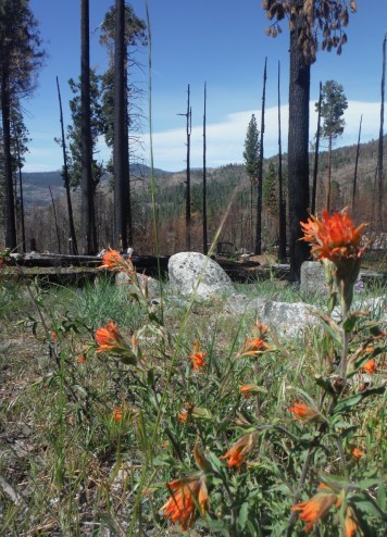
Wildflowers edging the burned forest
About 3 miles into the trail you hit the burned area, which was actually fairly well marked via cut logs and apparent walking paths. In the forest heading up Cottonwood Creek the trail occasionally becomes hidden under some needle fall, but keeping your eye on trampled path makes it not too difficult to navigate. No such luck once you reach Smith Meadow.
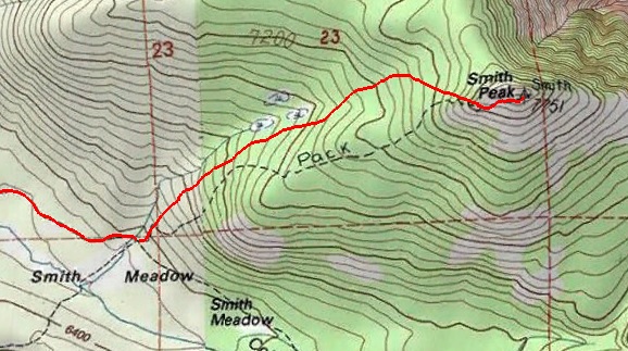
If I had to suggest a route I would following the creek until it disappears, then gradually swinging right towards the peak. This it pretty gradual climb and will ensure you don’t get too off route.
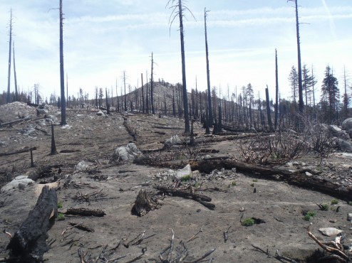
Past Smith meadow the short 1.5 miles to Smith Peak is pretty gnarly. The map shows the trail heading up the right side of the creek and travelling in a tangent straight up to the peak – I can count on one hand the number of times I felt like I was on this official path. The Rim Fire hit Smith Peak HARD, so there is no vegetation besides stumps and fallen trees, making everything and nothing simultaneously look like a trail. I ended up aiming to walk in burned manzinita field because there were less hazard trees in those areas to scare me every time the breeze picked up.
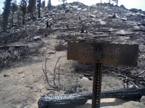
This sign is a sight for sore eyes after spending far too much time picking my way up the trail
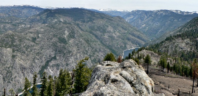
Smith Peak though – such a good view of the Sierra to Yosemite’s North and the impacts of the Rim Fire. I could spend a good chunk of time just identifying mountains, distant creeks, and tracing the skyline.
It is hard to recommend this hike in it’s current condition for a casual day hike, but if you are looking for a workout and want to see a fire impacted area, commence hiking with caution. Of course I’m sure in a year or so many of the hazard trees will have fallen and the trail will be more traveled – then I unequivocally recommend it. It is a beautiful spot.


")


 Hello! I am a 30-something outdoors-lady, backpacker, and resident of Groveland, California -
You finding any morels. Those burns can summon them.
Yes! I wish the hike in wasn’t so long or else I would be checking all the time.
Wow. I used to hike from Mather to Smith Peak back in the 1990s and almost the whole trail, except for the meadows was under forest cover. What a change.
Hello – Thank you for sharing. Could we have permission to use your image from Smith Peak overlooking Hetch Hetchy?