
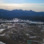
Gaylor Peak Hike
Tioga Pass isn’t opened yet – but since almost all of the other passes in our neck of the Sierra are open, I am channeling my anxiousness into a blog post about one of my favorite short hikes on Tioga Pass: Gaylor Peak. Specifically the first and most memorable time was the first during the strangely snow-less 2011-2012 winter, a December Hike with our friend from Michigan Tech, Kris. Or as I like to think of it: Midwesterners…
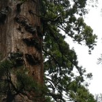
Big Trees Camping and North Grove Hike
Guess who had a birthday recently? This girl! It was hard to compete with last year’s birthday – in which I both completed my first half marathon (& only so far… I should fix that!) and had a fantastic Easter Sunday – but birthdays are not supposed to be a competition. If they were a competition then I would have stalled out after that time in which Jacquie made me that realistic…

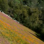
Red Hills Wildflower Hike
This is the best time of year to drive Highway 120 up to Groveland – green hillsides thanks to the recent rain and, as I noticed on my last drive down to Sonora, wildflowers lining the roadsides. On my drive I pass Chinese Camp, the very small town that is the portal to the BLM Area of Environmental Concern: The Red Hills, which I had recently blogged about this presidents day. Other than…
Hiking the Merced River Canyon – with a pup!
Trailhead: West of El Portal take the Foresta Rd bridge over the Merced, then immediatly turn left onto Incline Road. The narrow Incline road goes past many nice looking forest service campsites, then turns to gravel before you reach a gate. Park here and start hiking past the gate.
Distance: About 4.5 miles out and back (2.25 miles each way). The trail is really a service road that runs parallel to the North side of the river, which ends at where Hwy 140 crosses the North side Merced to via a small aluminum bridge to avoid a landslide that happened a few years back.


 Hello! I am a 30-something outdoors-lady, backpacker, and resident of Groveland, California -
Follow Me: