
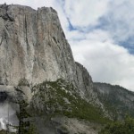
Upper Yosemite Falls Hike! & a Lesson in Trail Construction?
It is May in Yosemite and you know what that means – Waterfalls! The snow in the high country is melting and recently (well, last week at least) we have been receiving some hot summer type weather. Springtime is the best time for waterfalls every year, but less with the than average amounts of rain/snowfall this winter the waterfalls might dry out sooner rather than latter this year. :( This is Curtis…
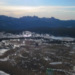
Gaylor Peak Hike
Tioga Pass isn’t opened yet – but since almost all of the other passes in our neck of the Sierra are open, I am channeling my anxiousness into a blog post about one of my favorite short hikes on Tioga Pass: Gaylor Peak. Specifically the first and most memorable time was the first during the strangely snow-less 2011-2012 winter, a December Hike with our friend from Michigan Tech, Kris. Or as I like to think of it: Midwesterners…
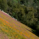
Hiking the Merced River Canyon – with a pup!
Trailhead: West of El Portal take the Foresta Rd bridge over the Merced, then immediatly turn left onto Incline Road. The narrow Incline road goes past many nice looking forest service campsites, then turns to gravel before you reach a gate. Park here and start hiking past the gate.
Distance: About 4.5 miles out and back (2.25 miles each way). The trail is really a service road that runs parallel to the North side of the river, which ends at where Hwy 140 crosses the North side Merced to via a small aluminum bridge to avoid a landslide that happened a few years back.
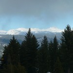
Yosemite Snowshoeing: Crane Flat Fire Lookout
Winter is almost over! Or, at least it seems that way since daylight saving time and 60 degree weather has started here in Groveland. But, since it did rain last week Curtis and I were able to Yosemite snowshoeing one more time this weekend. We ended up picking a classic, the Crane Flat Fire Lookout. We have cross country skied up to the lookout before, but I could return to again and…
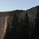
Yosemite Firefall 2013 & How to enjoy the Yosemite Sunset
This weekend I got to check an item off of my Yosemite Bucket List: seeing the Yosemite firefall! Curtis and I spent two evenings (Saturday and Sunday, February 23rd and 24th) among a flock of fancy cameras & photographers waiting for the sun to set in just the perfect way on Horsetail Falls. Except calling it “Horsetail Falls” is a bit of a stretch – perhaps we should temporarily label…
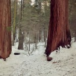
Snowshoeing the Merced Grove of Sequoias
Our trip snowshoeing the Merced Grove of Giant Sequoias allowed us to travel off trail to see a few of the Sequoias you can only peer at in the summertime.
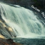
Carlon Falls for a December Hike
Trailhead: Evergreen Rd, Stanislaus National Forest – after bridge on South fork of Tuolumne River/ Opposite side as Carlon picnic area sign!
Distance: ~ 3.5 miles out and back. Trail is fairly level at first and then goes over a couple large hills right before reaching the falls.
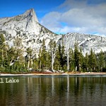
Lower Cathedral Lake Hike – A late fall hike
Trailhead: Tioga Rd / Hwy 120, on the West side of Tuolumne Meadows by the Cathedral Lakes sign. Parking here is pullout/parallel and usually a mess so you should see the line of cars as you approach.
Distance: ~7 miles (out and back). climbing mostly in the hike “out”, & descending in the back “back”
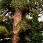
Mariposa Grove – Without an overpriced Tram Ticket!
Trailhead: Mariposa Grove Rd/Parking lot off of Hwy 41. Might be necessary to take a shuttle in peak times of year.
Distance: ~ 2 miles round trip to Grizzly Giant & Tunnel Tree. The trail is moderately sloped on the hike out.


 Hello! I am a 30-something outdoors-lady, backpacker, and resident of Groveland, California -
Follow Me: