
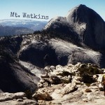
Day Hiking Mt. Watkins, Yosemite – Sweet Solace Off the Trail
Trailhead: Olmsted Point, off of Tioga Rd / Hwy 41
Distance: ~ 9 miles out and back. Trail is fairly level with just enough climb in the way out that you will appreciate gravity’s help on the way back.
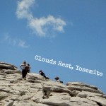
Day Hiking Clouds Rest, Yosemite – Resting with the Clouds
Trailhead: Sunset Lakes, Tioga Rd / Hwy 120 on the West end of Tenaya Lake
Distance: ~ 14 miles out and back. Good and steep on the way out, with downhill on the hike back.
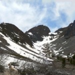
Lundy Canyon
Trailhead: Lundy Lake Rd (off of Hwy 395) past the lake & cabins down to dirt road pullouts near an Outhouse.
Distance: We hiked ~3.5 miles before we hit the snowline (Just beyond a dayhike to Mill Creek Falls), making it 7miles out and back. Trail was fairly hilly and required you to ford past runoff streams and cross some good old fashioned shady log bridge.
Tioga Road Biking
Did you know that it a not-so-secret time honored road biking tradition to travel over mountain passes after the snow melts but as the road remains closed? I didn’t, until we heard about being able to cycle Tioga Pass in the park! I cant tell you the last time Curtis and I REALLY road our bikes, other than going into town, so this was quite the change – and physical…
Bike Paths, Cold Rivers, and Trail Markers
Curtis and I had planned to bike around wine country this weekend, but, as we should have expected, it was your traditional end of September scorcher of a day. Instead we decided to take the opportunity to swim in Yosemite, and bike around the valley there. We had been avoiding the valley all summer because of the hoards of people everywhere. I enjoy people watching to a degree, but we…
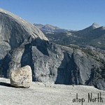
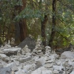
North Dome, Not the North Pole
Trailhead: Porcupine Creek Trailhead, off of Tioga Rd / Hwy 120
Distance: ~9 miles. Slightly downhill on way out and then uphill on the way back. The end of this hike take you onto granite slopes and it is probably best if you wear some shoes with traction & not your foam Tevas like I did.
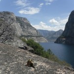
Hetch Hetchy Day Hike or as we like to call it Hetch Hedgehogy: the story of our water source and a brave hedgehog
Trailhead: Evergreen Rd down into Hetch Hetchy Entrance Station, parking lot by dam
Distance: ~ 4 miles rounds trip to Wapama Falls, we went ~ 1.5 miles past that and in addition got to see rattlesnakes & bears!
Day Hiking Inspiration Point, Yosemite: Our second trip focusing on an Inspiration.
Trailhead: Behind Tunnel View, off of Hwy 41 right outside of the Valley
Distance: ~ 2.5 miles, but filled with steep switchbacks and hot in the summer sun!
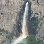
Valley Floor Day Hike instead of unpacking!
Trailhead: Parked by Bridal Veil Falls (parallel because parking area was full) in the Valley.
Distance: ~4 miles ( we walked there on the trail and back partially along the road/bike paths) Flat with but unexpected hills compared to the road.


 Hello! I am a 30-something outdoors-lady, backpacker, and resident of Groveland, California -
Follow Me: