
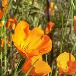
Spring Wildflower Identification in the Merced River Canyon
Spring has started – and wildflower season too! I didn’t end up hiking on the Hite’s Cove trail, but did see a TON of wildflowers, and not just poppies. Using my amateur botanist skills I have created Beaut-tree.net’s first wildflower guide: the Merced River Canyon Spring Wildflower Guide
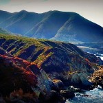
Camping Andrew Molera State Park in Big Sur
I’m not going to lie, whenever I am car camping anywhere new I worry about not finding space to camp. A pretty justified fear thanks to past experiences, like the time we reserved a campsite at Butano State Park and someone still tried to take our spot. I mean the people who we ended up sharing the spot with had assumed they could find a spot, and then they couldn’t –…
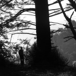
Tanbark Trail Big Sur: Hiking at Julia Pfeiffer Burns SP
Following Saturday’s short hike to the beautiful McWay Falls in Big Sur I was adamant about wanting to go for a longer day hike. Unfortunately the trail I had noted to hike, the Ewoldsen Trail, is apparently closed right now (March 2013)… but looking at the maps in the parking area of the McWay Falls trailhead Curtis & I discovered that the previously closed Tanbark Trail was now open instead, and it did look like a very similar, although slightly longer, hike.
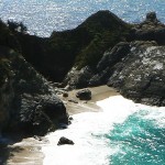
Pfeiffer Big Sur State Park Camping & Hiking McWay Falls
Tourist season is almost upon us again up in Groveland – slowly the local businesses are livening up, we are beginning to see a steady flow of traffic Yosemite, and I can hear the PML golfers outside teeing more and more often. These changes made me realize that if I wanted to go to any traditional popular tourist locations I had better get moving now, or face the higher prices and thicker crowds that true summer tourist season demands. Impetus enough for Curtis & I to make our (moderately spontaneous?) trip to Big Sur this weekend!
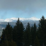
Yosemite Snowshoeing: Crane Flat Fire Lookout
Winter is almost over! Or, at least it seems that way since daylight saving time and 60 degree weather has started here in Groveland. But, since it did rain last week Curtis and I were able to Yosemite snowshoeing one more time this weekend. We ended up picking a classic, the Crane Flat Fire Lookout. We have cross country skied up to the lookout before, but I could return to again and…
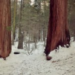
Snowshoeing the Merced Grove of Sequoias
Our trip snowshoeing the Merced Grove of Giant Sequoias allowed us to travel off trail to see a few of the Sequoias you can only peer at in the summertime.
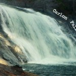
Carlon Falls for a December Hike
Trailhead: Evergreen Rd, Stanislaus National Forest – after bridge on South fork of Tuolumne River/ Opposite side as Carlon picnic area sign!
Distance: ~ 3.5 miles out and back. Trail is fairly level at first and then goes over a couple large hills right before reaching the falls.
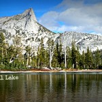
Lower Cathedral Lake Hike – A late fall hike
Trailhead: Tioga Rd / Hwy 120, on the West side of Tuolumne Meadows by the Cathedral Lakes sign. Parking here is pullout/parallel and usually a mess so you should see the line of cars as you approach.
Distance: ~7 miles (out and back). climbing mostly in the hike “out”, & descending in the back “back”
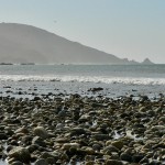
Our one day in Big Sur
For as much as I have heard about how beautiful Big Sur is I didn’t really know much about Big Sur. What I did know: there would be cliffs with magnificent ocean views, a relatively underpopulated coastline, and (thanks to my Mom) that there was some famous bridge there. It was with this minimal knowledge that my parents started down Coastal Hwy 1 towards the Bixby bridge and some dot on the map called “Big Sur” to see…


 Hello! I am a 30-something outdoors-lady, backpacker, and resident of Groveland, California -
Follow Me: