
Hiking Old 49 to the Drowned Town of Melones
The winter rains have finally started here in the Motherlode – in fact today I went skiing up at Crane Flat! It is exciting to finally see water falling from the sky! Although, As the rain started I immediately regretted all the wasted drought opportunities which I thought about but didn’t get around to this year. Don’t get me wrong, we need the rain… but so see the old reservoirs reduced to the old river levels is something both mysterious, magical, and reminiscent. Reservoirs symbolise progress… by downing the old, which of course to a point of progress.
To make up for lost time I quickly did an analysis of the nearest and most likely accessible local drowned historical sites, which unfortunately meant nixing the old Exchequer Dam (which is pretty illegal to try to access without permission), and ended up with an alright plan for finding the town of Malones.
Exploring Old Highway 49 to find Historic Malones, California
Trailhead: Start at the intersection of the old 49 route with the current highway 49. It is a short ways North of the Stevenot Bridge spanning the reservoir. The old 49 alignment is a paved and gated road on the east, reservoir facing, side of the highway between Carson Hill and bridge. Map
Distance: The GPS showed the walk as 4 miles, which includes a good deal of exploring and walking around once reaching the ruins. GPS Track
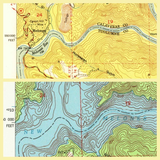
1949 USGS Columbia topographic quad versus 2001 quad. Clearly the area is normal inundated.
Unlike when we visited the lookout of the Eagle-Shawmut Mine we did not have any insider info on how to navigate down the reservoir to this drowned settlement. I simply googled as much as possible, then compared the 1949 Columbia topo map to the current one. Unless if the BOR took the time to completely rip out the old 49 alignment (unlikely considering these old structures were not demolished before the reservoir was raised), it would still be there – albeit a little worse for the wear.
As I found it the old 49 alignment is still in place weaving down to the reservoir, and strangely passing what looks to a be a parking area the Bureau built to allow parking for recreation down near the old town site. Currently this area is only accessible by foot, and displays new looking “Protect our Natural Resources” signs installed at varying points along the walk down. These signs seem a bit ironic given these sites were drowned, but all the same I know I enjoy finding them as is now and would be disappointed if the old ruins were disturbed any further.
Following a history similar to the Don Pedro’s Jackson, the New Melones Reservoir was once a smaller storage reservoir built by the Oakdale and South San Joaquin Irrigation Districts, the town of Melones was also drowned following a raising of the reservoir in the 1970s. Originally named Robinsons Ferry for the ferry service that crossed the Stanislaus River the town was renamed Melones after the mining town and stamp mill moved into the location.
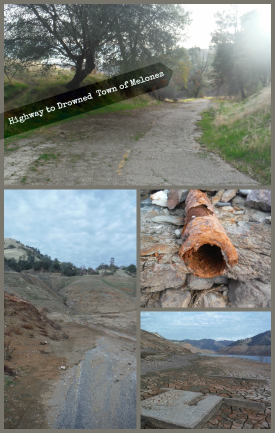
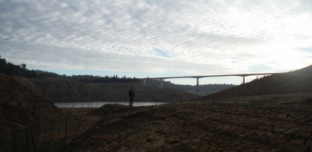
As it is following the old road down I found the old Carson Hill Mine site more than the actual town of Melones. Here there are foundations, old pipes, and a hole in the hill that I am willing to bet is remnant of the mine. The earth here has cracked after becoming exposed to sun and air after being hidden beneath the reservoir for a long time. They are interesting and bleak looking ruins. While walking down the old road I could imagine classic old cars driving these aged switchbacks, but it is harder to imagine a recent history here beith the reservoirs typical surface. They are called ‘Ruins‘ for a reason.
More photos in the gallery below:
")
")
")
")
")
")
")
")
")
")
")
")
")
")
")
")
")
")
")
")
")


 Hello! I am a 30-something outdoors-lady, backpacker, and resident of Groveland, California -
Great pictures. Saw some video of another mine now showing. Entrance was caved in, but tailing piles in the area are interesting.