
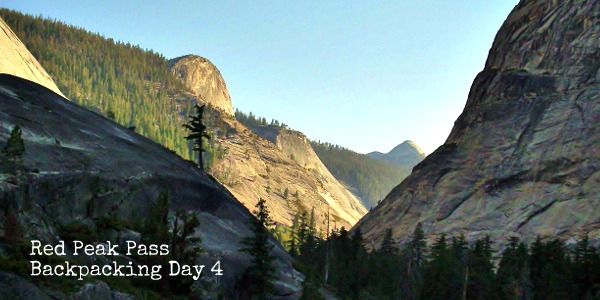
Merced River to Little Yosemite Valley – Backpacking Red Peak Pass Day 4
Map of Loop
Curtis & I hiked Red Peak Pass in Yosemite for 5 days and 4 nights. It was 50 miles of mountains, lizard push-ups, rivers, and lakes. Check out the blog post detailing each day’s ups, downs, and tips: Day 1, Day 2, Day 3, Day 4, Day 5
Or continue on to read of day 4’s adventures…
On day four we awoke to flick the last 8 or so sleeping mosquitoes off the screening to the tent and start off the longest hiking of the trip. The goal: Little Yosemite Valley… or wherever we would give up at. Since I was fairly upset at the number of mosquitoes present on the this side of the pass I was pretty determined to hike, like we have never hiked before, to get closer to the exit on Sunday.
Hiking down canyon we had slept above the night prior we ran into the first people we had seen in 23 hours. The couple was hiking down from Tuolumne meadows the opposite way and warned us of the crazy amount of tree fall ahead, but offered optimism about decreased bug numbers after Washburn Lake (True, less mosquitoes, more flys, thank you!).
I wish we had recorded their conversation for repeat directions, because the tree fall ahead was much worse than the one we went through on the first day. We scrambled on a previous scrambled path next to the Merced, passing the bridge (with a useful bridge closed sign nailed on the middle of the bridge along with felled trees) and instead crossed in our sandals slightly further downstream. There we had to continue to follow down the stream along a small turn in the river (and to my imagine mind back towards where we came, sorry for whining Curtis!) to find the trail.
Until this point in the hike I had not been overly hot, but as we passed Washburn lake July finally crept up on us! HOT! I was pretty jealous of the family of ducks we passed that were floating upstream of a waterfall like no one’s business. I was convinced we were going to get to swim in Merced Lake once we got there, and was in enough of a mood to consider stopping at the Merced Lake backpacking camp. Which leads to this pro tip about Merced lake: not super for swimming, lots of marshy plants & muck.
Instead Curtis and I elected to cool off by placing our feet in the water and I continued to massage them in the sand. I was unaware of this, but burrowing you feet in the sand for a massage and flexing feet in child’s pose by tucking your toes under you is one of the more rejuvenating ways to bring back tired feet on the brink of quitting. Eating your emergency ration of basil (the spice, not the rabbit) seasoned olives also helps. Thus we renewed determination we made down the trail, meeting up with all backpackers we have not seen in the last 3 days (Q: Do you always say hello to fellow backpackers? Is there a point when there is too many and you should stop?).
Between Merced Lake and Little Yosemite was in my mind the best scenery of the hike that day. As the trail wraps around Bunnell Point the Merced looks like one big waterfall and the granite rises around you. Even more amazing (but not even worth try to capture an image of with the camera we had on us) was the small slit like canyon the river rushes though before it reaches the Lost Valley area and cascades over a granite waterfall.
Tree fall in Lost Valley made it difficult to find a spot to camp there (although thankfully these trees were cleared from the trail), and we ended up in the Moraine Dome Backpacking Camp in Little Yosemite Valley. The camp is not well marked (only at the end of it is there a “Day use only” sign to tell you that you apparently passed the camp), but it was good to be done after more than 14 miles.


 White Fir")


 Hello! I am a 30-something outdoors-lady, backpacker, and resident of Groveland, California -
I liked the pictures very much Denise and Curtis. I also like the narative.You have a way with words,always have.thanks for sharing,loveto you